Home
The Oregon Department of Transportation (ODOT) Southern Oregon Activity-Based Travel Demand Model (ABM) is a new travel demand model for the Middle Rogue and Rogue Valley MPOs. The new modeling system is based on the CT-RAMP family of ABMs and includes 50,000+ persons in Grants Pass and 175,000+ persons in the Rouge Valley urban areas.
Compared to traditional trip-based models, the model system has more detailed and accurate representation of space, time, travel patterns, and significantly more person and context-based explanatory variables. The ABM better models non-motorized travel, time-of-day, ride sharing, non-home-based travel, accessibility effects, and provides a flexible household travel survey-like database for custom summaries. This modeling system was also developed as the eventual framework for exploring new policy issues: new vehicle types and emissions, parking and different pricing scenarios, connected and automated vehicles, vehicle ownership moving to service, light-weight vehicle infrastructure, telecommuting, and others. These new questions are anticipated to increase and evolve with each passing year, and the new microsimulation-based ABM is the best tool available.
This travel demand model is based on the CT-RAMP (Coordinated Travel Regional Activity-Based Modeling Platform) family of ABMs. The CT-RAMP framework, which is fully described in the model specification, adheres to the following basic principles:
- The CT-RAMP design attempt to model individual travel choices with maximum behavioral realism. In particular, it addresses both household-level and person-level travel choices including intra-household interactions between household members.
- Operates at a detailed temporal (half-hourly) level, and considers congestion and pricing effects on time-of-day and peak spreading.
- Reflects and responds to detailed demographic information, including household structure, aging, changes in wealth, and other key attributes.
- Is implemented in the Common Modeling Framework (CMF), an open-source library specifically for implementing advanced travel demand models.
- Offers sensitivity to demographic and socio-economic changes observed or expected in the dynamic Southern Oregon metropolitan region. This is ensured by the enhanced and flexible population synthesis procedures as well as by the fine level of model segmentation. In particular, the model incorporates different household, family, and housing types including a detail analysis of different household compositions in their relation to activity-travel patterns.
The model integrates with the ODOT Statewide Integrated Model (SWIM) for external flows, includes a commercial vehicle model, uses open matrix (OMX) for data interchange, Google transit for transit routes, TomTom for observed speed data, and utilizes ptv's VISUM for all network level-of-service information and zonal data management.
Activity-based models can exploit more explicit geographic and location information, but the advantages of additional spatial detail must be balanced against the additional efforts required to develop zone and associated network information at this level of detail, as well as against the increases in model runtime associated primarily with path-building and assignment. The use of a spatially disaggregate zone system helps ensure appropriate model sensitivity. Use of large zones may produce aggregation biases, especially in destination choice, where the use of aggregate data can lead to illogical parameter estimates due to reduced variation in estimation data, and in mode choice, where modal access may be distorted. Smaller zones help minimize these effects, and can also support more detailed network assignments. Strategies to address the modal access limitations of large zones through the use of transit sub-zonal procedures are discussed in the transit network section of this document.
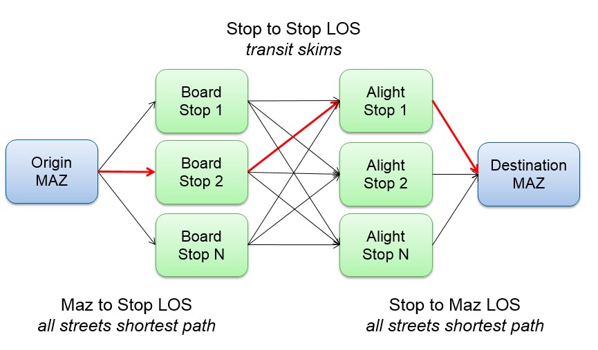
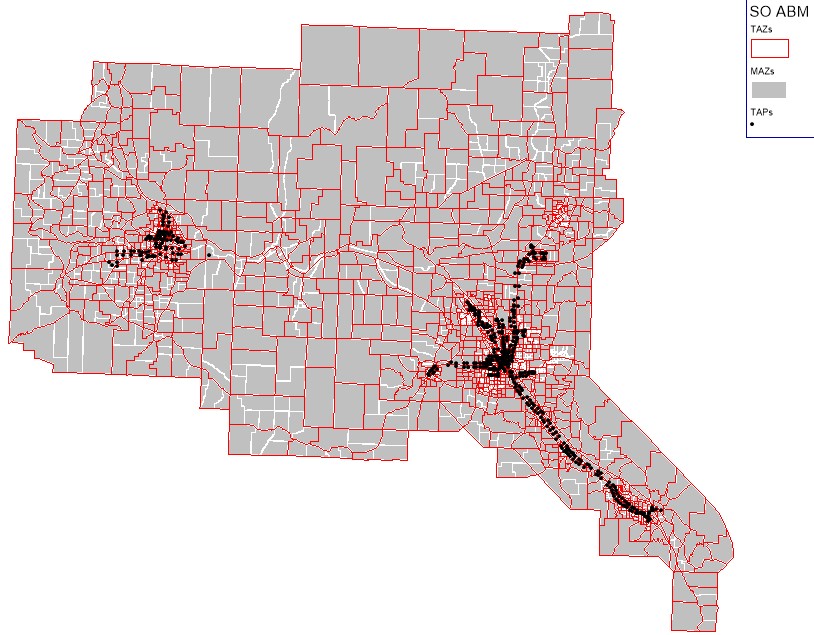
The new model has three zone systems – microzones (MAZs) for modeling non-motorized travel such as walk, bike, and transit access/egress, Transportation Analysis Zones (TAZs) for auto travel, and transit access points (TAPs), also called ‘stop areas’ (VISUM's terminology), for modeling transit trips from stop to stop, as shown below.
All transit access and egress calculations and ultimate transit paths from origin MAZ to destination MAZ through boarding and alighting TAPs are computed within OR-RAMP, and rely upon detailed geographic information regarding MAZ-TAP distances and accessibilities. A graphical depiction of the MAZ – TAP transit calculations is shown below.