Try to remove clouds from sentinel images #27
SteffenCucos
started this conversation in
Ideas
Replies: 2 comments
-
|
Very cool Idea! So far I've found some theoretical stuff:
And even some examples and tutorials:
|
Beta Was this translation helpful? Give feedback.
0 replies
-
|
This seems to be a very real and relevant Topic. (Especially the ML-approach looks very interesting for me) I'd like to delve much deeper into the Subject but unfortunately I have not the time for that. |
Beta Was this translation helpful? Give feedback.
0 replies
Sign up for free
to join this conversation on GitHub.
Already have an account?
Sign in to comment
-
The current approach to generating sentinel images is to overlay 4 days worth of images to "plug" the holes that they have (gaps in the coverage of an area for a given day). This approach creates a full image, but doesn't always leave you the "best" possible image, as the output is order dependent and doesn't account for which images have better land coverage.
I have my own approach at solving this that looks at each image on a per pixel basis and does its best to avoid using pixels from clouds.
Here is an example over Italy that showcases how much land you can recover from the images that mostly get ignored.
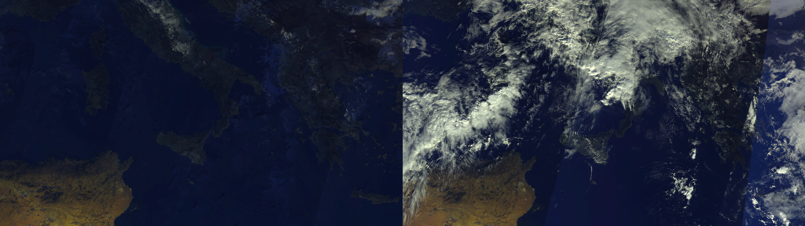
Left: Without clouds
Right: Current image generation
Here is the source for this approach. It is by no means perfect, as you can clearly see artifacts in the water and over darker parts of land, but overall the landmass is much more visible. Also note that this approach is VERY slow atm. It's doing math, list sorting, and object generation on a per pixel basis. This can easily be parallelized though. You could work on parts of the image in parallel, then stitch them together at the end.
Beta Was this translation helpful? Give feedback.
All reactions